
Winter Outlook 2026–27
Milder, wetter, and worth watching: our official winter outlook
By Matt Douglas, Chief Observer, Blue Hill Observatory & Science Center
For the first time, Blue Hill Observatory’s official winter outlook was produced by our own Chief Observer, Matt Douglas. It draws on a mid-October assessment of the ocean and atmospheric patterns that shape North American winters.
The headline: a strong El Niño favors a milder, wetter winter for New England. Pushing back against it are signs that Arctic air will escape south in bursts. That tug of war means a more changeable season than usual, with periodic cold shots and a higher chance of coastal storms.
What it means for New England
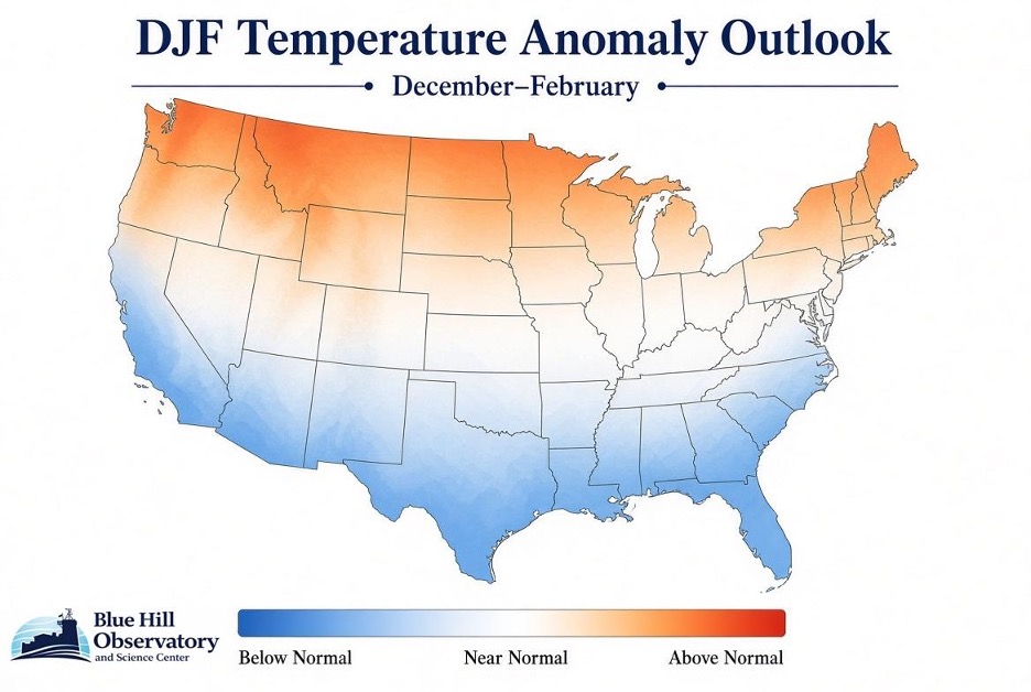
Temperature: above normal. Milder overall, interrupted by short cold-air outbreaks.
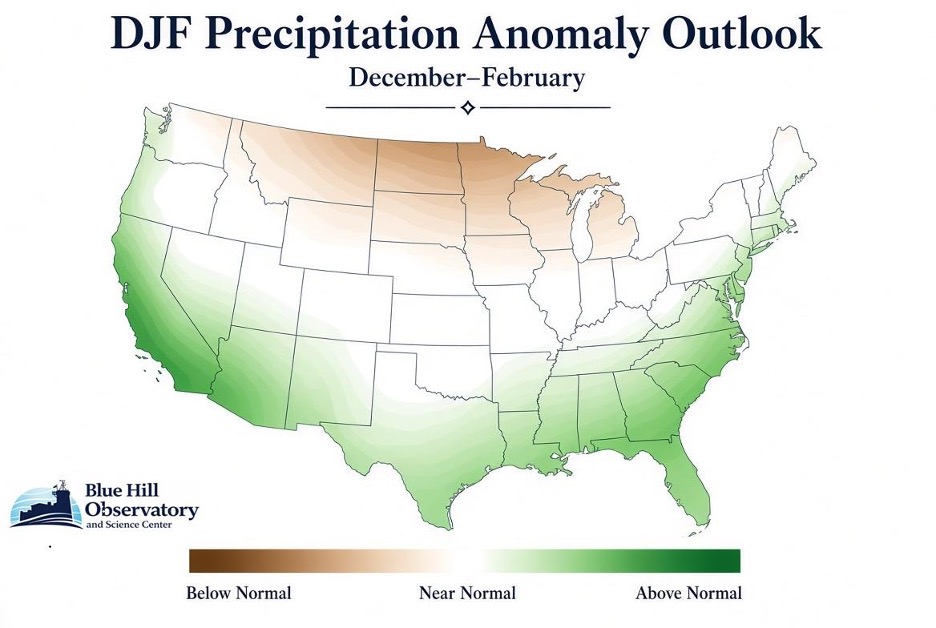
Precipitation: above normal along the coast. An active storm track reaches up the East Coast into coastal New England.
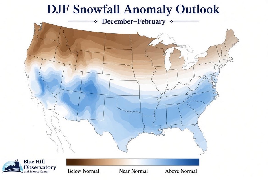
Snowfall: below normal. Boston is projected to get 25 to 30 inches, about half its normal 49. Significant snowstorms remain possible whenever cold air and the storm track line up.
The outlook maps
Snowfall projections for southern New England
Season totals, December through February.
| City | Normal | Expected 2026–27 | % of normal |
|---|---|---|---|
| Boston, MA | 49 in. | 25–30 in. | ~50–60% |
| Worcester, MA | 70 in. | 50–60 in. | ~70–80% |
| Springfield, MA | 50 in. | 30–35 in. | ~60–70% |
| Providence, RI | 36 in. | 18–23 in. | ~50–60% |
| Hartford, CT | 48 in. | 35–40 in. | ~75–85% |
Across the country
Temperature. Above-normal temperatures are favored across the northern tier, from the Pacific Northwest through the northern Rockies, upper Midwest, and Northeast. The southern Appalachians and Ohio Valley trend near normal. The southern tier, from the Southwest to the Southeast, is favored to run cooler than normal under extra clouds and storminess.
Precipitation. Above-normal precipitation is expected from California and the Southwest through the southern Plains, Gulf Coast, and Southeast, extending north along the East Coast into the Mid-Atlantic and coastal Northeast. Parts of the northern Rockies and far northern Great Lakes lean near to slightly below normal.
Snowfall. Above-normal snowfall is favored in the Sierra Nevada and southern Rockies, and from Texas east across the Gulf states and Southeast into the Mid-Atlantic and central and southern Appalachians. The Pacific Northwest into the western Great Lakes leans below normal. The central and eastern Great Lakes and Ohio Valley trend near normal, and New England leans near to below normal.
What’s driving this winter
Seasonal outlooks weigh the large patterns in the oceans and atmosphere that tilt the odds for a whole season. This year several of them disagree, so overall confidence is low to moderate.
El Niño: strong and east-based
The dominant influence. The warmest water sits in the far eastern equatorial Pacific, which strengthens the subtropical jet stream and drives an active southern storm track. On its own, this pattern points to a mild northern winter and a wet, stormy South.
Arctic and North Atlantic Oscillations: likely negative at times
These pressure patterns control how easily cold air leaves the Arctic. In their negative phases, often paired with a weakened polar vortex, high pressure builds over Greenland, the jet stream dips south, and storms slow down along the East Coast. This is the main reason the Northeast is not forecast to be as persistently mild as a pure El Niño winter, and it supports the higher odds of coastal storms.
Quasi-Biennial Oscillation: positive
A band of stratospheric winds over the equator that flips direction about every 28 months. Its positive phase tends to keep the polar vortex steadier, a mild counterweight that makes a prolonged deep freeze less likely than in other years.
Madden-Julian Oscillation: active
A large pulse of tropical thunderstorms that circles the globe every 30 to 60 days. Depending on its phase, it can amplify El Niño’s storm track or let the Arctic patterns take over for a while. It is a big reason we expect more week-to-week swings than usual.
Pacific Decadal Oscillation: positive
A slow pattern in North Pacific ocean temperatures that can hold for years. Its positive phase works in the same direction as El Niño, adding confidence to the classic El Niño storm track and the mild northern baseline.
Atlantic Multidecadal Oscillation: positive
Warmer than average North Atlantic waters can fuel East Coast storms. This is one of the factors extending the wetter-than-normal signal up the Atlantic seaboard.

Meet the forecaster
Matt Douglas is Blue Hill Observatory’s Chief Observer. He brings nearly 35 years of experience observing and forecasting the weather.
Matt grew up in Milton in the shadow of Great Blue Hill, and weather has been a lifelong passion. When he isn’t watching the sky, he’s into aviation, baseball, and cooking.
We will track how the season unfolds against this outlook. Watch the summit live on our webcams and follow storm coverage on the Significant Weather Blog.
Giving Tuesday is December 1
Every forecast starts with the record
This outlook exists because someone has watched the sky from the summit every day since 1885. Your gift keeps the observers, the instruments, and the record going into its next century.
Give to Blue Hill Observatory


