Editor’s Note: While Blue Hill Observatory does not issue forecasts and does not endorse this forecast, we thought our readers would enjoy hearing what a leading winter weather expert is predicting. Joe D’Aleo is a certified meteorologist and the first Director of Meteorology at the Weather Channel. He is currently Co-Chief Meteorologist at WeatherBell Analytics, LLC.
THE WILD WINTER OF 2013-14.
COULD IT REPEAT?
By Joseph D’Aleo, CCM
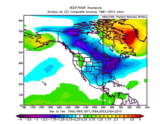
The Winter of 2013-14 was wild over North America. The media and the public were caught by surprise. At WeatherBell, we were warning clients of the possibility of an historic winter in July and went full bore cold by Thanksgiving.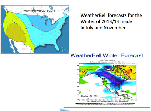 The actual December to February temperature anomalies were very much in line with our forecast.
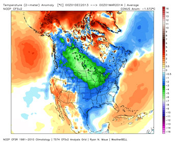 Chicago had its coldest December to March on record (since 1872), Detroit its snowiest on record (since 1880). It was third snowiest in Chicago behind only 1977-78 and 1978-79. It was the second snowiest in Philadelphia.
Ice on the Great Lakes was the greatest on record, peaking at 92.2% and above normal in every week. Ice flows were seen on Lake Superior in early June.
It stayed cold into the spring, with the coldest weather shifting eastward. Vermont had its coldest March on record, with a statewide temperature of 18.3°F (8.9°F below average). The previous coldest March in Vermont occurred in 1916 when the monthly average temperature was 18.6°F. Maine and New Hampshire each had their second coldest March on record. Massachusetts had its eighth coldest March, and Connecticut its ninth coldest.
Weatherbell employs a different approach in seasonal forecasting. We do analog forecasts statistical models based on ENSO (by ENSO region) and the many other major oceanic and solar oscillations. We also use the Quasi-Biennial Oscillation (QBO), which CPC had found modulated the effects with ENSO and measures of solar activity.
Last year the Atlantic Multidecadal Oscillation (AMO) and Pacific Decadal Oscillation PDO became confused and ENSO was neutral. The real driver was the record warm pool (5 standard deviations positive) in the Gulf of Alaska and a strong westerly QBO (both favoring a western ridge, strong central trough that became the ‘Polar Vortex’.
Of course the polar vortex is not new and in fact it is there in all seasons. It is stronger in winter and especially in some parts of the hemisphere and its amplitude varies. Last winter, it was stuck in central North America and it was deep.
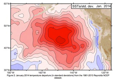 Jerome Namias, the first Director of the Long Range Forecasting branch of what was then called the US Weather Bureau (long range then was 5 days!) focused on the ocean influence on the jet stream and his research convinced him that cold and warm water pools outside the tropics had an effect by anchoring the mean long wave troughs and ridges. He used them in his seasonal forecasts at Scripps. He wrote a paper and explained to me at a conference how the warm water that developed during the strong string of La Niñas in the early to mid 1970s led to a western US trough and a warm southeast. Once the currents carried it to the Gulf of Alaska in 1976, the pattern flipped with three incredibly cold winters.
Joe Bastardi and I noted the same thing happened between 1916-1918, with two record setting winters and to some degree in 2002 to 2004. That is what made us so bullish cold on last winter (and next winter).
If it feels like winters are getting colder and snowier to you, your perception is correct. NOAA has reported, www.ncdc.noaa.gov/cag/, that meteorological winter (December – February) temperatures in the contiguous United States have trended downward at a rate of 0.36°F per decade over the last 25 winters, 1.13°F per decade over the last 20 winters, and 2.26 °F per decade over the last 10 winters.
For the past 20 years, every one of the 9 climate regions has shown a downward trend in winter temperatures.
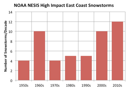
As for snowfall, just 4 years into this decade, we have had more high impact east coast snowstorms (Kocin -Uccellini storms) than any decade since the 1950s.
 For the hemisphere, 4 of the top 5 snowiest years have occurred since 2007-08. AS of late last week, snow in Russia was running well ahead of normal and is building this week in North America..
The warm pool is still in the Gulf of Alaska. El Niño is trying to come on and will likely do so but be biased toward the central Pacific. This is the El Nino pattern (called the Modoki) that is cold for the eastern U.S. The QBO has flipped strong easterly, which favors a broader cold over the lower 48 states and enhanced high latitude blocking to trap the cold air over the continents in mid-latitudes. A four to six week period of intense cold seems likely midwinter.
Our analogs favor the return of the dreaded ‘polar vortex’ but with the coldest air biased farther to the east and south. We have any warmth (and it is not much) limited to the far northwest. There should be plenty of snow, especially from southern New England towards the south and southwest. The snow should start early and continue into February. Our analogs suggest once the snow melts in March, March and April should bring early spring warmth.
 Join us at Weatherbell.com to get the daily details in blogs and videos by Joe Bastardi, Tom Downs, Dr. Ryan Maue and I along with global and regional temperature and precipitation anomaly mapping, teleconnection tracking, and the best global models including the highest resolution European model output available. Stay warm!!!!!!