
2025 Summary – Warmer, Drier and Sunnier Than Average
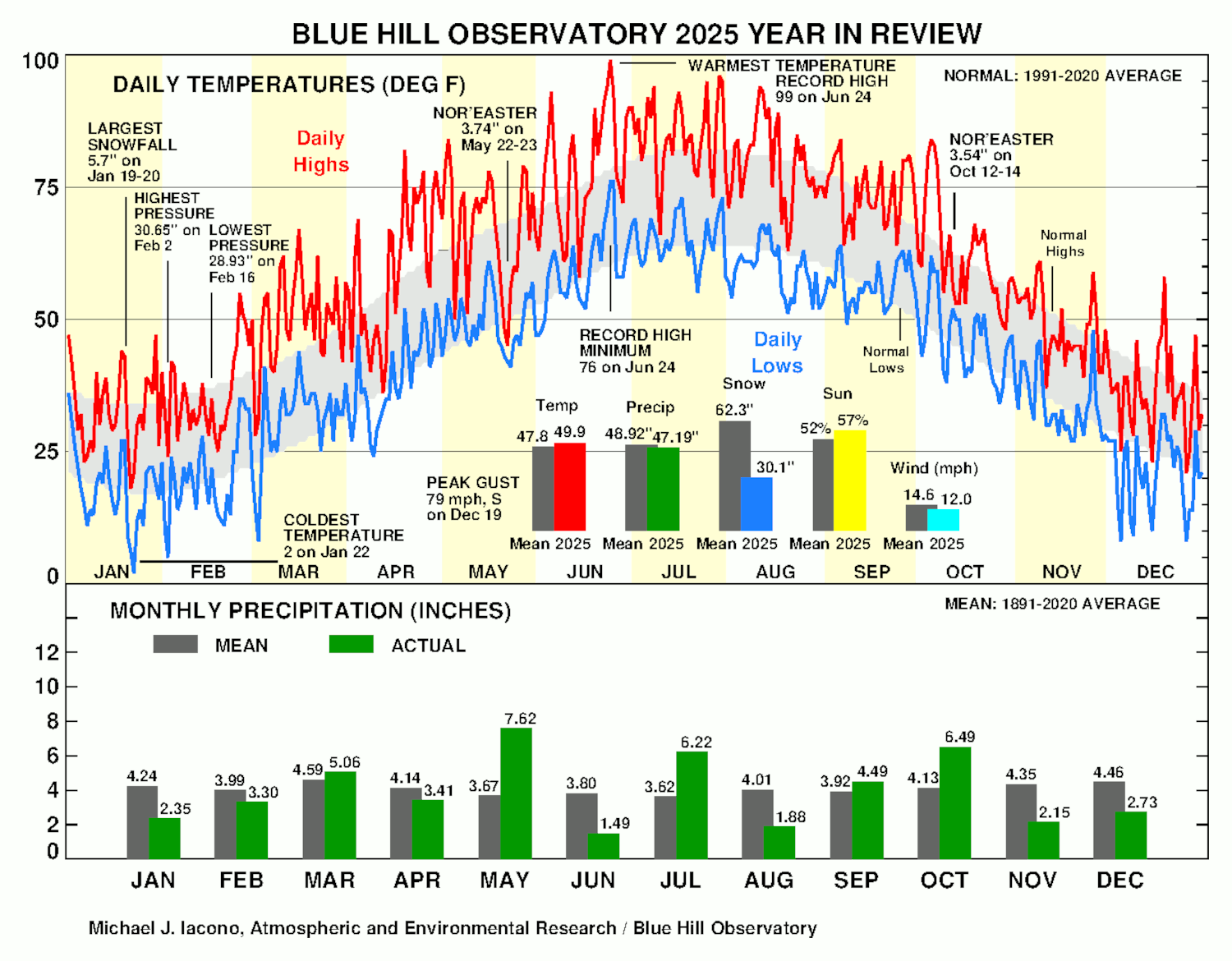
The year 2025 was warmer than average, but it was the coolest year since 2019. The approximated 24-hour mean temperature of 49.9F was 2.1F warmer than the 130-year (1891-2020) long-term mean and 0.4F above the 30-year (1991-2020) average. Ten months during the year were warmer than the long-term mean and two, January and December, were colder than average. The annual average maximum temperature of 59.1F was 0.8F warmer than the 30-year normal, and the annual average minimum temperature of 41.6F was 0.5F warmer than the 30-year normal.
The year started cooler than average, turned warmer during spring and summer with April through July all being among the ten warmest on record, then cooler weather returned later in the year. January was generally cooler than average, and the coldest temperature for the year was 2F on January 22nd. Cold weather continued into much of February until the last week of the month when a high of 55F occurred on February 25th. March turned warmer with 23 days warmer than normal. April had 13 days with high temperatures of 65F or more, including the highest of 82F on April 19th, and the month was the seventh warmest on record. May generally continued the warmth as the eighth warmest on record with the exception of cold weather during a strong nor’easter on May 22nd-23rd, which brought a high temperature of only 45F and a low of 42F on May 22nd. Spring (March-May) 2025 tied as the fourth warmest on record at the Observatory. June was the eighth warmest on record and included seven days that reached or exceeded ninety degrees, which was the largest number of ninety-degree days ever observed in June at Blue Hill. A four-day heat wave occurred on June 22nd-25th, which was one of only three four-day heat waves ever recorded in June at Blue Hill. The highest temperature for the year was 99F on June 24th, which matched the highest temperature ever measured at Blue Hill during June and surpassed the previous record for the date of 91F set in 1914, 1976, and 2013. The second highest daily minimum temperature ever observed in June of 76F was recorded on June 24th and 25th. July was the tenth warmest on record and added eight more ninety-degree days to the annual total of 18, which was eleven more than the long-term average number. Somewhat cooler weather began to return in August, except for a relatively warm period during the second week of the month. September and October were slightly warmer than average with a three-day period of 80F or higher as late as October 4th-6th. Cooler weather returned in November, though the first freeze of the season (temperature of 32F or lower) did not occur until November 7th, which tied as the eighth latest date on record. After seven straight warm Decembers, December 2025 was colder than average and the coldest since 2017, though there were only a few brief periods of Arctic air during the month and no daily records were established.
Ponkapoag Pond and Houghton’s Pond were first considered frozen for the 2024-2025 winter season during the first half of December 2024, and due to the cool start to 2025, the ponds were considered thawed for that season on March 11th (Ponkapoag) and March 15th (Houghton’s). The freeze interval during that season of 97 days (Ponkapoag) and 89 days (Houghton’s) was slightly shorter than the long-term average. At the start of the 2025-2026 winter season, both ponds were considered first frozen on December 6th, which was a few days earlier than the long-term average date.
The annual rainfall of 47.19 inches was 1.73 inches less than the 130-year average and 6.67 inches less than the 30-year normal. The year started off dry with only 2.35 inches from a handful of precipitation events and no significant storms in January. February added slightly to the deficit, with 1.95 inches of liquid equivalent, more than half of the month’s precipitation, falling as a combination of rain and snow on the 15th-16th. Essentially all of the March precipitation fell as rain, with only a few traces of snowfall, and the largest storm in March brought 2.17 inches of rain on the 16th-17th. Despite 15 days with measurable precipitation, April contributed more than an inch to the annual rainfall deficit. Above normal precipitation returned in May, which brought 7.62 inches of rain, and the month was the eighth wettest May on record. The largest event was a major, late-season nor’easter, which brought 3.74 inches of rain and cold temperatures on May 22nd-23rd. After a dry June, July was very wet, though most of the monthly rain, 4.94 inches, fell during three days with thunderstorms on July 8th-10th, including 2.46 inches over a two-hour period on the morning of July 10th. The greatest rainfall amount in 24 hours during 2025 was 3.85 inches on July 10th. August was relatively dry with only five days with measurable precipitation. September rainfall was near average, with the largest event bringing 2.02 inches on Sep 6th-7th. October featured two significant storms including a coastal storm that brought 3.54 inches of rain on the 12th-14th. The second was a strong inland storm that brought a tropical feed of moisture, strong winds, and 0.96 inches of rainfall on the 29th-31st while a weakening Hurricane Melissa passed far out at sea. Both November and December brought about half of the expected precipitation for those months, though there were frequent moderate events during December. More than twenty inches of the annual rainfall fell during only seven events on sixteen days during the year. There were 22 thunderstorm days during 2025, which matched the average number.
Snowfall was sparse during 2025 with an annual total of just 30.1 inches, which was far less than the recent 30-year normal of nearly 70 inches. The largest snowfall event all year was 5.7 inches on January 18th-19th. Other notable snow events brought 4.1 inches on February 8th-9th, 4.9 inches on February 15th-16th, and 3.6 inches on December 26th-27th. There was just one inch of snow on the ground on Christmas Day morning, which qualified the day as a “White Christmas” at Blue Hill. The long-term chance of a snow depth of one-inch or more on December 25th on the summit of Great Blue Hill is 44 percent.
The mean station pressure during 2025 at the elevation of the mercury barometer at the Observatory was 29.31 inches, which was 0.02 inches above the long-term annual mean of 29.29 inches. The maximum sea-level pressure during the year was 30.65 inches on February 2nd, and the lowest sea-level pressure during 2025 was 28.93 inches just two weeks later during a rain and snow storm on February 16th.
One of the more unusual metrics recorded at the Observatory is the date of the first ripe blueberry on the summit of Great Blue Hill. In 2025 this was observed to occur on June 23rd, which a couple of days later than the long-term average date. In general, this date is trending earlier due to the warming climate.
Water vapor pressure, which is derived from the dew point and is an absolute measure of the amount of moisture in the air in terms of the pressure that water vapor contributes to the total surface pressure, averaged 10.6 mb (0.313 inches) during 2025, which corresponded to a mean dew point of 46 deg F. The annual vapor pressure continued a trend of higher water vapor pressures in recent decades, which is consistent with the increasing trend in temperature. Another way to interpret this value is to state that water vapor on average comprised a little over one percent of the total annual mean station pressure during the year.
The annual mean wind speed of 12.0 mph, while higher than the last two years, tied as the fifth lowest on record for any year. This average continued the several decades long trend of decreasing mean wind speeds on Blue Hill. One month during the year, September, tied the record for the lowest average wind speed for that month, 9.4 mph, previously set in 2024. The prevailing wind direction for 2025 was west-northwest. The peak gust for the year was 79 mph from the south prior to the passage of an Arctic front on December 19th. Other notable wind gusts during the year included 65 mph from the west-northwest on January 28th, 70 mph from the west-northwest on February 17th, and 69 mph from the south on March 6th.
Bright sunshine for the year was 57 percent of possible, which was five percent more than the long-term average. The least sunny month as a percent of possible was May with only 175.1 hours or 40 percent of the possible bright sunshine. The sunniest month during 2025 (relative to the possible sunshine) was August, which had 305.1 hours or 74 percent of the possible sunshine. The August sunshine was enough to make that month the sunniest August on record. For the year, 2025 was the fourteenth sunniest year on record.
BHO Lowest Annual Mean Wind Speed, mph (1885-2025):
1) 10.8 in 2023
2) 11.2 in 2024
3) 11.5 in 2021
4) 11.8 in 2012
5) 12.0 in 2020
12.0 in 2022
12.0 in 2025
8) 12.1 in 2018
12.1 in 2019
Mike Iacono
Chief Scientist
Blue Hill Observatory


