
2015 Was Warmer, Drier and Sunnier Than Average
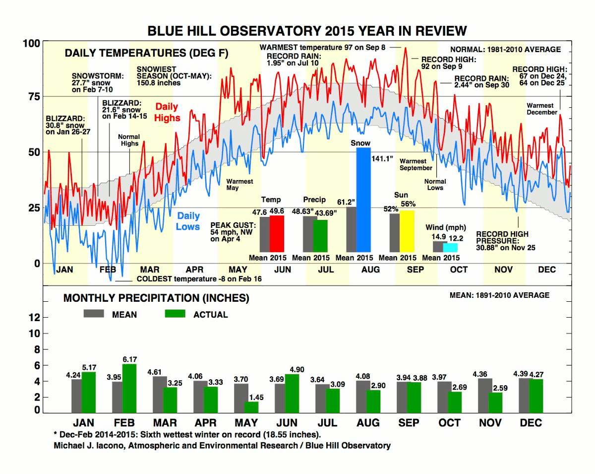
The year 2015 ended with a 24-hour corrected mean temperature of 49.6F, which was 2.0F warmer than the 120-year mean and 0.7F above the 30-year normal. This was the fifteenth warmest year on record and the warmest since the record year of 2012. The year got off to a frigid start with a cold January and March and the third coldest February on record, but the next nine months were all near or warmer than the long-term average. The first three months of the year combined were the ninth coldest on record for that period and the coldest since 1934. The coldest temperature during 2015 was -8F on February 16th, and a total of five days in January and February had minimum temperatures below zero. Later in the year, three months established new records for the warmest month, including May, September and December. The maximum temperature for the year was 97F on September 8th, which was the second warmest temperature ever measured in September and the warmest so late in the season. Three consecutive days in the 90s on September 7th-9th provided only the second heat wave ever observed in September (the other occurring in 1895). There were eight 90-degree days in 2015, two more than the long-term average, and three of these occurred in September. The last month of the year was consistently warmer than average with seven days that were twenty degrees or more warmer than normal with four such days in a row from December 22nd-25th. The maximum temperatures on December 24th (67F) and December 25th (64F) both set new daily records.
A residual effect of the cold weather in February and March was the very late thaws of two local ponds this year. Houghton’s Pond was considered free of ice on April 10th, which tied for the second latest thaw date ever observed, and Ponkapoag Pond was considered thawed on April 11th, which was the latest thaw date on record for that pond in the last 130 years. Yet only two months later, the first ripe blueberries were observed on the summit on June 12th, which was about nine days earlier than the long-term mean date.
Annual precipitation totaled 43.69 inches, which was about five inches drier than the 120-year average and about ten inches less than the 1981-2010 30-year average. This was the driest year since 2012. Only three months during 2015 exceeded the long-term average precipitation: January, February and June. The remaining months were all drier than average, with May being the driest month with only 1.45 inches. February brought the most liquid equivalent precipitation of any month with 6.17 inches. There were 16 days with thunderstorms during the year, which was six fewer than average. Several extreme rainfall events occurred during the year. Downpours associated with strong thunderstorms brought 2.03 inches in a few hours on July 9th-10th, which included a new daily record of 1.95 inches on July 10th. Tropical rains along a cold front brought a total of 2.53 inches on September 29th-30th, and this included a new daily record of 2.44 inches on September 30th. A precipitation total of 1.58 inches fell in less than 24 hours on October 28th-29th in heavy rainfall that was in part associated with the remnants of Hurricane Patricia.
Snowfall for the calendar year was excessive with a total of 141.1 inches, or about 80 inches more than the long-term average of 61 inches, and this surpassed the previous record of 125.2 inches in 1996. Most of this snowfall, 126.5 inches, fell in the snowy months of January and February 2015. The January total of 42.9 inches made this the eighth snowiest January on record, and the February total of 83.6 inches was a new record for any month of the year surpassing 65.4 inches in February 1969. Much of this snow fell in about three weeks from late January to mid-February due to a series of several historic snowfalls and blizzards including 30.8 inches on January 26th-27th (the second greatest snowstorm on record), 16.5 inches on February 2nd, 27.7 inches on February 7th-10th (the 7th largest snowfall on record), and 21.6 inches on February 14th-15th. The snow depth on the summit of Great Blue Hill reached a maximum of 46 inches on February 15th, which was also a new record for the Observatory. The final seasonal snowfall for 2014-2015 was 150.8 inches, which surpassed the previous seasonal record of 144.4 inches in 1995-1996.
The mean station pressure on the summit of Great Blue Hill during 2015 was 29.34 inches, which tied with 1906, 1911, 1946, and 1949 for the highest mean station pressure for any year on record since 1885. This is 0.05 inches higher than the long-term annual mean of 29.29 inches. The highest sea-level pressure during the year was 30.88 inches on November 25th, which tied for the highest sea-level pressure ever measured in that month with a similar reading in November 1932. The lowest sea-level pressure during 2015 was 29.16 inches on January 24th, which occurred during the moderate snowfall on that date that started the intense period of cold and snow that lasted into February.
The annual mean wind speed of 12.2 mph tied for the second lowest on record with 2013, behind only the 11.8 mph mean observed in 2012. This continues the several decade long trend of decreasing mean wind speeds on Blue Hill. The peak wind gust for the year was only 54 mph from the NW during a thunderstorm on April 4th. This was the lowest peak gust for an entire year in the last 50 years.
Bright sunshine for the year was very high at 56 percent of possible, which was four percent more than the long-term average, and this was the most bright sunshine for any year since 2007.
BHO Greatest Annual Snowfall, inches (1885-2015):
1) 141.1 in 2015
2) 125.2 in 1996
3) 124.4 in 1967
4) 122.4 in 1956
5) 116.3 in 1945
6) 112.0 in 2003
7) 111.9 in 2005
8) 110.2 in 1916
9) 108.1 in 1904
10) 104.4 in 1948
BHO Lowest Annual Mean Wind Speed, mph (1885-2015):
1) 11.8 in 2012
2) 12.2 in 2013
12.2 in 2015
4) 12.3 in 2014
5) 12.5 in 2011
6) 12.6 in 2008
12.6 in 2009
BHO Lowest Annual Peak Wind Gust, mph (1965-2015):
1) 54 W in 2015
2) 62 S in 2014
3) 64 W in 2001
4) 67 ENE in 2010
5) 68 S in 2005
BHO Highest Annual Mean Vapor Pressure, mb (1885-2015):
1) 11.0 in 2012
2) 10.9 in 2011
3) 10.7 in 1973
4) 10.6 in 1979
10.6 in 2006
6) 10.5 n 1949
10.5 in 2013
10.5 in 2015


